ACHD Marigold Street Concept Study
Please scroll down.
Welcome
Online Public Meeting
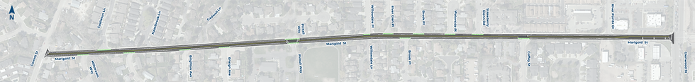
ACHD and Garden City are studying improvements to the Marigold Street corridor between Garrett Street and Glenwood Street.
As a key Garden City route with connections to City Hall, the library, the Greenbelt and more, Marigold is used by those walking, biking and driving. This study looks at how to make this busy street function better for everyone.
How to Participate
We value your feedback and encourage you to participate in the following ways:
Online
Please review the information here and complete the survey at the end.
Renderings in this online meeting are for illustrative purposes only.
Study Description & Purpose
Description
ACHD initiated this study to evaluate current cut-through traffic patterns and to research options to influence driver behavior and create a safer environment for all roadway users.
The design team has produced a striping plan and six concepts that include:
-
Striping changes
-
Intersection improvements at:
-
Garrett Street and Marigold Street
-
Coffey Street and Marigold Street
-
Glenwood Street and Marigold Street
Purpose
Improve safety for motorists, pedestrians and bicyclists.
A significant number of pedestrian-vehicle crashes have occurred in the study area.
Discourage cut-through traffic by adding street design features that slow car speeds and make bicyclists and pedestrians more visible.
Help reduce cut-through traffic on Marigold by encouraging drivers to use nearby main roads and avoid residential streets.
Evaluate how intersections on Marigold Street are functioning and identify ways to improve current traffic flow for users.
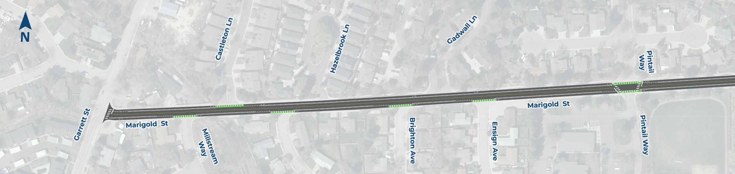
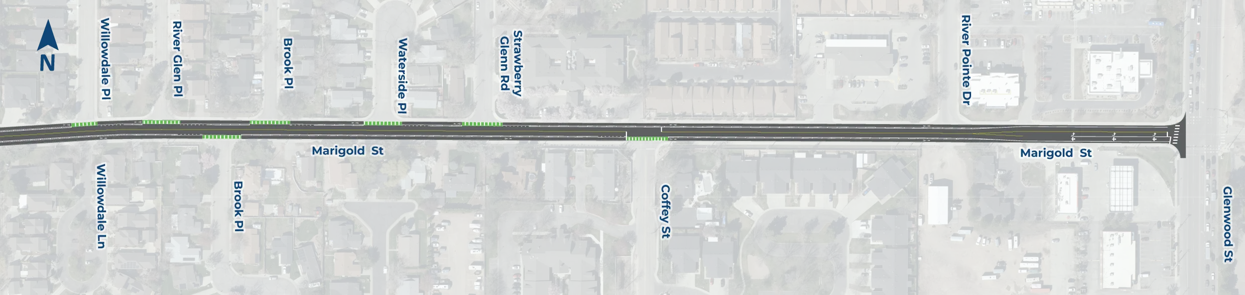
Street Restriping Plan
A street restriping plan was developed to kick off improvements that will increase safety for pedestrians and bicyclists. Marigold Street is identified in ACHD’s Bike Master Plan as a future low-stress bicycle route. The existing striping does not include sufficient bike facilities and it makes the corridor less comfortable for bicyclists.
Marigold will be resurfaced with chip seal in 2027. Additional improvements are proposed for implementation in 2027, including:
1. Remove the center turn lane.
2. Add six-foot bike lanes with a two-foot buffer between bikes and cars.
3. Preserve existing pedestrian ramps, curb, and sidewalk.
4. Install flashing LED stop signs on Marigold Street at Coffey Street intersection.
If the project progresses, it may be implemented with the 2027 chip seal program.
Click the image to open
Click the image to open
Intersection Concepts
ACHD identified three intersections along Marigold Street with the intention of making changes to reduce cut-through traffic and increase safety by slowing speeds and better accommodating bicyclists and pedestrians.
We need your feedback on the following six concepts (two concepts per intersection).
Only one concept per intersection will be advanced for additional review and possible implementation. Construction timeline and funding have not yet been established.
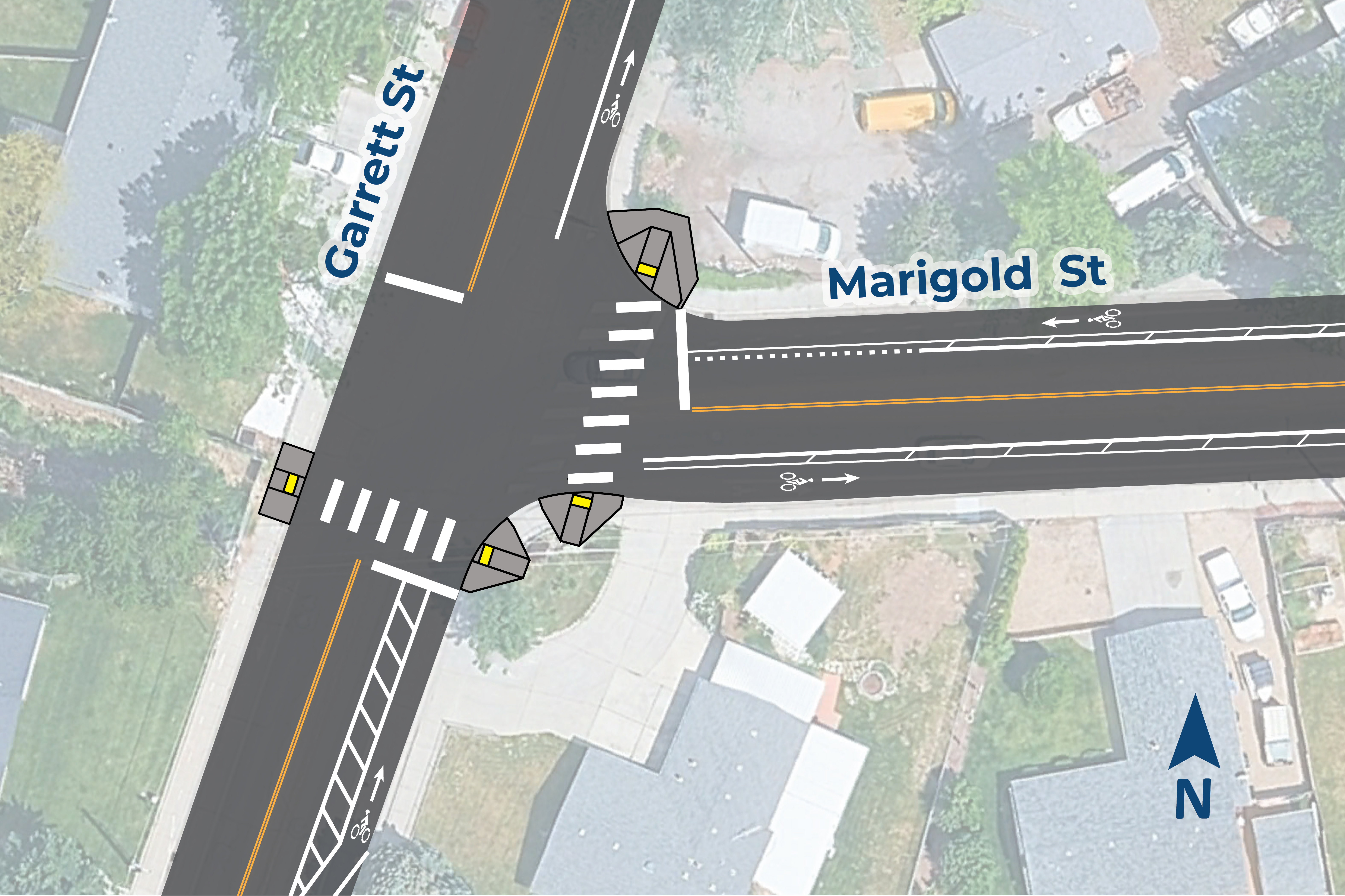
Concepts A1 & A2:
Garrett Street and Marigold Street Intersection
Concepts A Goal: Increase safety by adding striping or physical barriers.
Concept A1: Standard Protected Bike Lane
Updated pedestrian ramps and curbs.
Separated northbound bike lane on Garrett Street.
New east/west crosswalk on Garrett Street.
Click the image to open
Concept A2: Vertically-Protected Bike Lane
Updated pedestrian ramps and curbs.
Separated northbound bike lane on Garrett Street.
Right-turn channelizing island.
A small, raised-concrete island that guides right-turning vehicles and can provide a safer place for bicyclists to wait while crossing or while turning right.
New east/west crosswalk on Garrett Street.
Click the image to open
Concepts B1 & B2:
Coffey Street and Marigold Street Intersection
Concepts B Goal: Reduce traffic speeds and increase safety for everyone.
Concept B1: Mini Roundabout with Mountable Center Island
Roundabout intersection with mountable center island.
Pedestrian refuge islands.
Multiuse path.
Rectangular Rapid Flashing Beacon (RRFB) for pedestrian crossings.
Green bicyle ramp transitions with warning surfaces.
Updated pedestrian ramps and curb.
Click the image to open
Concept B2: All-Way Stop
Flashing LED stop signs.
Bike lane markings through intersection.
Updated pedestrian ramps and curb.
Click the image to open
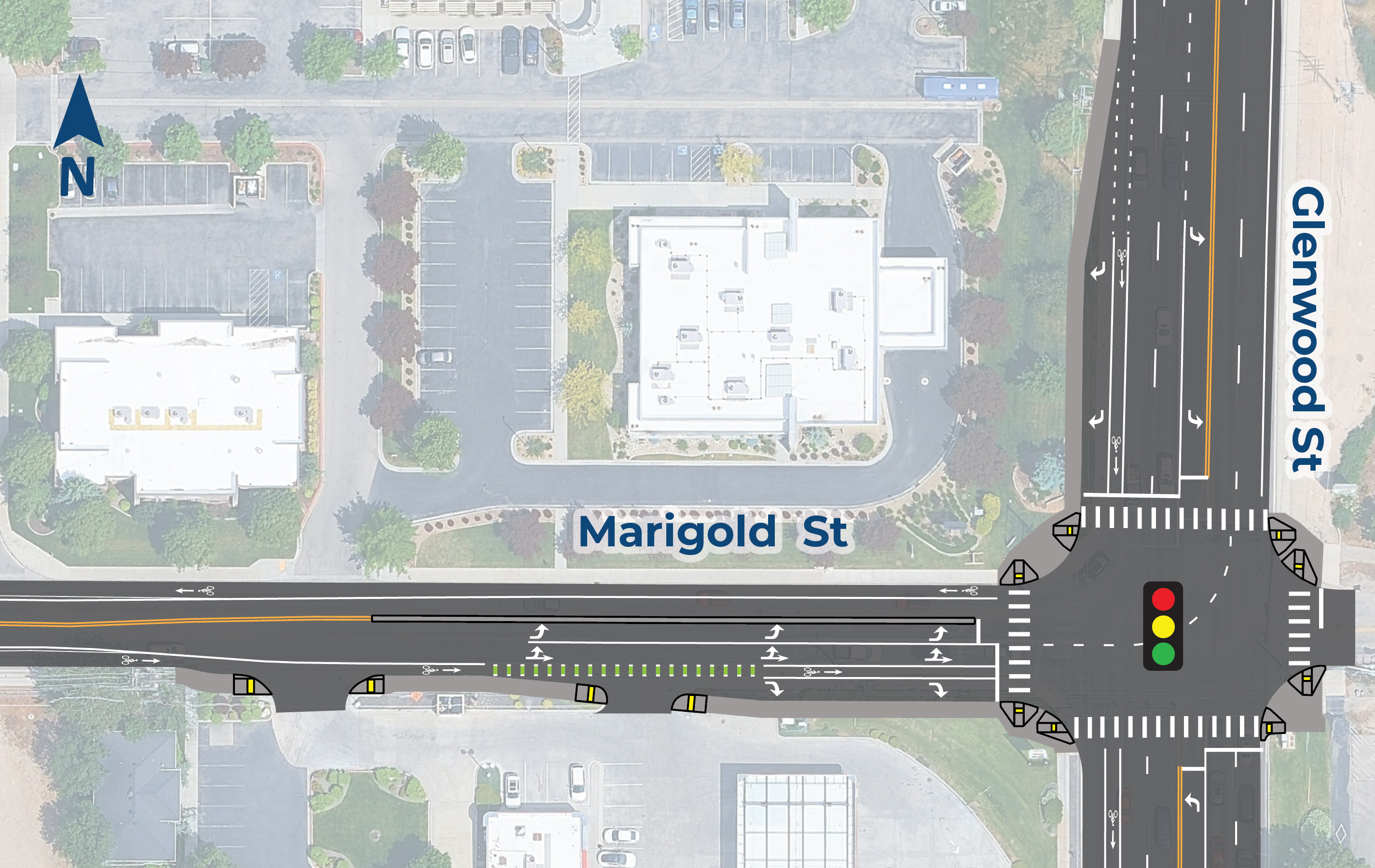
Concepts C1 & C2:
Glenwood Street and Marigold Street Intersection
Concepts C Goal: Improve intersection functionality and safety for all roadway users
Both Concepts Include:
-
Updated pedestrian ramps and curb.
-
Concrete traffic separator on Marigold Street.
-
Bike lane markings on Marigold Street approaching intersection.
-
Dedicated eastbound right-turn lane onto Glenwood Street.
-
Dedicated southbound right-turn lane onto Marigold Street.
-
Dedicated bike lane at intersection.
-
Bike lane will not extend onto Glenwood Street.
-
Concept C1: Road Widening North of Current Alignment
Requires reconstruction of intersection’s east leg to match lane angles.
Increased lane shift for westbound Marigold drivers.
Bike lane shift could conflict with drivers leaving Jacksons, turning right at Glenwood Street.
Click the image to open
Concept C2: Road Widening South of Current Alignment
Intersection’s east leg remains as is.
No lane shift for westbound Marigold drivers.
Bike lane continues from Marigold to intersection with no shifts.
Click the image to open
What do you think?
We Want to Hear From You
After reviewing the information for the Marigold Street Concept Study, please fill out the community feedback survey and tell us what you think about the intersection concepts. Your input will help the project team determine which intersection concepts to evaluate in more detail.
While your comments are always welcome, they can be best used if received by June 10, 2026.
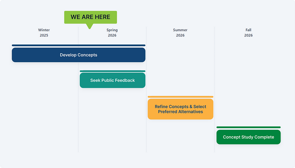
Schedule and Next Steps
Only one concept per intersection will be advanced for additional review and possible implementation. Construction timeline and funding have not yet been established.
Stay Informed
Sign up for study notifications on the project webpage.
For questions or more information, contact:
Rebecca Phillips
ACHD Transportation Planner
(208) 385-6100
or
TTY: 1-800-377-3529
To arrange for a translator or other accommodation,
contact ACHD at (208) 387-6100 | TTY 1-800-377-3529 | achdidaho.org/access
Se recomienda a las personas que necesiten un intérprete u otras acomodaciones que se pongan en contacto con ACHD al numero de telefono (208) 387-6100 | TTY 1-800-377-3529 | achdidaho.org/access